Recently developed remote sensing tools and geographical information system (GIS) strategies are enabling researchers and governments to map and inventory national carbon stocks quickly, cheaply and at an unprecedented level of detail. The maps follow on production of the first “high-fidelity” maps of forests and carbon stocks, which was produced for Panama last year.
Gathering an unprecedented level of detail on tropical forest and biomass across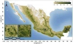 Mexico and Peru, research teams have been able to produce inventories of carbon stocks for both countries that could prove invaluable as countries around the world chart pathways to reduce deforestation and land degradation, carbon dioxide (CO2) and greenhouse gas (GHG) emissions, and foster sustainable development.
On October 16th, the Woods Hole Research Center (WHRC) and Mexico’s Allianza MREDD+ released the first detailed map of Mexico’s above-ground forest carbon stocks. As highlighted in a news report from Phys.org:
“This carbon stock inventory is very valuable for Mexico, as one of the first tropical nations to voluntarily pledge to mitigation actions within the context of the United Nation’s Reducing Emissions from Deforestation and forest Degradation (REDD+) program.”
Mapping, monitoring forests, carbon stocks
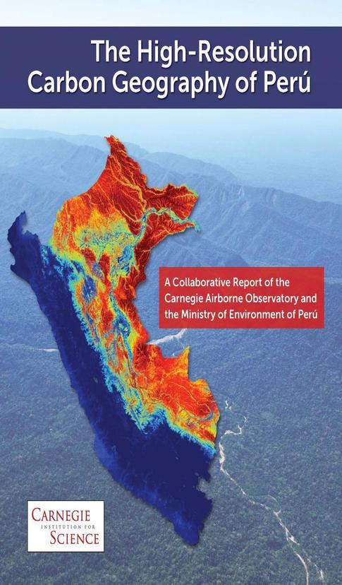
In Peru, scientists employed a new high-resolution mapping strategy and tools to produce a national inventory of tropical forest cover and carbon stocks. As explained in Phys.org’s November 11 news report, the maps and data set can be used to prioritize “carbon conservation efforts throughout tropical countries.”
The most biodiverse terrestrial ecosystems on the planet, tropical forests are also the Earth’s largest carbon sinks, absorbing, assimilating and storing more CO2 than any other. Along with forest fires, clearing tropical forests for agriculture, energy and mineral resource extraction and development accounts for some 10 percent of global carbon emissions a year.
The new mapping tools and strategies used in Mexico and Peru could prove invaluable for governments and societies worldwide in terms of aligning goals of social and economic development and environmental conservation.
As Carnegie Institute lead researcher Greg Asner highlighted:
“We found that nearly a billion metric tons of above-ground carbon stocks in Peru are at imminent risk for emission into the atmosphere due to land uses such as fossil fuel oil exploration, cattle ranching, oil palm plantations and gold mining. The good news is that our high-resolution mapping was able to identify three strategies for offsetting these upcoming emissions.”
A team of researchers led by Asner combined advanced 3D forest mapping data gathered by the Carnegie Airborne Observatory with data from satellite images to produce “a map of carbon density throughout the 128-million hectare (328 million acre) country of Peru, at a resolution of one hectare (2.5 acres),” according to Phys.org’s report.e
The project’s low cost means it could be replicated in short order in any country, enabling them to craft national strategies and meet international commitments to reduce greenhouse gas emissions and foster sustainable development.
“Research is necessary to determine the exact state of our forests,” Manuel Pulgar-Vidal, Peru’s Minister of Environment, was quoted as saying. “For that, the Carnegie Institution, with the support of the Peruvian Environment Ministry, has developed the first high-resolution map of Peru’s carbon stocks.
“This new map provides the evidence needed to start negotiating in the carbon market at a bigger scale. Our government is also studying carbon stocks in the soil, and is doing a forest inventory, and we have a forest investment program. These initiatives will better prepare us to face changes in land use.”
UN Framework Convention on Climate Change (UNFCCC) negotiators are to meet in Peru’s capital, Lima, this December for the UNFCCC’s 20th annual Conference of Parties (COP 20). There, they’ll aim to resolve differences and reach an accord regarding global efforts to cap and reduce CO2 and greenhouse gas emissions, including setting the terms of a successor to the Kyoto Protocol.
